Region
 |
|
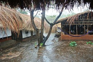
Rain season in Thuma |
The Wildlife Action Group (WAG) is an NGO, who co-manage two governmental protected areas Thuma Forest Reserve and Dedza-Salima Forest Reserve which are located in the Central Region of Malawi between Lilongwe and Lake Malawi on the escarpment of the Great Rift Valley. Together the two forest reserves cover an area of app. 500 qkm.
Generally, the topography is rugged. Slopes are steep although there is some flatter land at the foot of the escarpment. The upper levels of reserve are covered with Brachystegia (miombo) woodland whilst the lower levels are characterized by mixed low altitude woodland with patches of bamboo. Along the many streams within Thuma F.R., the habitat can be typified as riverine forest. Both reserves fulfil an important water catchment function for the area.
Location and Organisation
 |
|
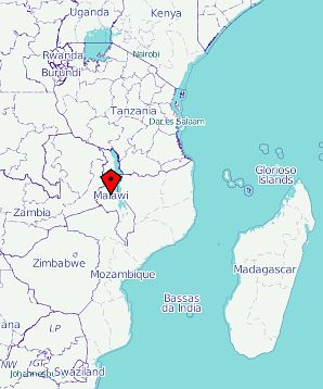
Source: OpenStreetMap.org |
Country: The Republic of Malawi
Population: 15.6 million (UN, 2010)
Capital: Lilongwe
Area: 118,484 sq km (45,747 sq miles)
Major languages: English, Chichewa (both
official)
Major religions: Christianity, Islam
Life expectancy: 56 years (men), 57 years
(women) (UN)
Monetary unit: 1 Malawi kwacha (MK) = 100
tambala
Main exports: Tobacco, tea, sugar,
cotton
GNI per capita: US $280 (World Bank,
2009)
Internet domain: .mw
International dialling code: +265
WAG's base camp is
situated in the Central region of Malawi, approx 90km
from Lilongwe. Our nearest town is Salima Town, near Senga
bay, which is a 1 hour drive from camp.
From the main tarmac road leading from Salima to Lilongwe we
turn off onto a dirt road and travel approx 19km to reach our
main gate entrance. We travel another 9kms of rough track
through the Reserve to reach main Camp.
-> External link: Thuma camp at www.openstreetmap.org


